(To blog readers: My son is traveling to Greece in April with a group from Massachusetts’ Oliver Ames [OA] High School [see March 5 post]. To give students and parents a glimpse of some of the places on the group’s itinerary and to provide links to sites the travelers may find helpful, I’m devoting 10 consecutive daily posts from March 22 through March 31 to places on the kids’ Greek itinerary. [I can’t think of a better place than Greece to hang, really or virtually, but if you’d like to go elsewhere, cruise the archives to visit scores of other great places, from Jamaica to Jordan, Malta to Mexico.] Wherever you end up, Kalo taxidi! Have a good trip.)
The Corinth Canal both divides and connects. Cut through a narrow neck of land between the Attic and Peloponnesian peninsulas, the four-mile-long waterway separates Athens and Greece’s northern mainland from the storied cities – Corinth, Mycenae, Nafplio, Epidauros, Olympia, Mystra, Sparta – of the Peloponnese, a rocky, mountainous land filled with mystery and antiquities.
While it separates Greece’s mainland regions, the canal, only 82-feet wide and 26-feet deep, unites bays and gulfs and oceans to allow ships of up to 10,000 tons to move between the Adriatic and Ionian seas north and west of Greece and the Aegean, south and east, without negotiating the long water route around the Peloponnesian peninsula.
As they head for their visit to ancient Corinth, the OA kids may get a glimpse of the canal from the Corinth superhighway, an ugly stretch of high-speed concrete that’s carried over the canal by a high bridge (background in above photo). But blink, and you’ll miss the canal: eighty-two feet goes by quickly when you’re rolling along at 60 miles per hour. (In fact, since the bus driver will be doing all the work, the Corinth superhighway is a good place for the OA kids to snooze and rest up for a night out in Nafplio, because the roadside scenery between Athens and Corinth, while interesting in the what-makes-this-area-tick sense, is largely unattractive and chock-full of heavy industry, oil refineries, cranes and shipyards, and tankers plying the Saronic Gulf.)
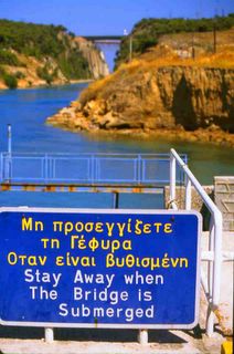
There is a viewing area on the highway road bridge, but better views of the canal can be had by lowering oneself to its level. At Isthmia, where the above photo was taken, you can stand on the small bridge that crosses the waterway and leads into town – a bridge mechanically lowered and submerged when a ship enters the watery conduit. Standing here, looking up at the canal’s 260-foot-high severe rock walls and down its unerringly straight deep-blue length, you realize you’re staring at a spectacular undertaking, something that took a mix of dreamers, madmen, geniuses, logical thinkers, engineers and strong-backed laborers to create.
Begun in 1882 by a French company that went bankrupt and left the scene, the Corinth Canal was completed by the Greeks in 1893. But traders since ancient times have tried to turn the Isthmus of Corinth into a Peloponnesian shortcut. As early as the 7th century B.C., a Greek ruler tried, unsuccessfully, to chop through the Isthmus. In A.D. 67, Emperor Nero himself attended a canal ground-breaking ceremony. When the Romans and their army of laborers, mainly Jewish slaves from Palestine, were interrupted by the small matter of uprisings in Gaul, canal work stopped completely. So, until 1893, merchants wishing to avoid sailing around the entire Peloponnese moved their ships across the narrow spit of land the old-fashioned way: they hauled them. On the canal’s west end, at Possidonia near Corinth, one can see traces of the ancient diolkos, the ruts and slipways used to drag ships, on chariots or wooden rollers, between seas now connected by the Corinth Canal.
Comments or questions? Email me
www.LoriHein.com
